The Peninsular Plateau
The Great Indian Plateau, which is the biggest physiographic region in India, is located to the south of the Great Northern Plains. It covers approximately 16 lakh square kilometers, which is equivalent to half of the total area of the country.
Basic Facts-
- The region's topography comprises of plateaus, hill ranges and river valleys.
- The Aravalli hills demarcate the north-western boundary of the plateau region.
- The northern and north-eastern boundaries are marked by the northern edge of the Bundelkhand Plateau, Kaimur and Rajmahal Hills.
- The Western Ghats (Sahyadry) and the Eastern Ghats serve as the western and eastern boundaries, respectively.
- Anaimudi peak (2965 m) is the highest point in the plateau region.
- The general slope of this plateau is towards the east.
- The entire plateau measures about 1700 km. in north-south and 1400 km. in east-west direction.
- It is an ancient tabular block composed mostly of the Archean gneisses and schists.
The general slope - of the plateau is from west to east with an exception of Narmada and Tapi rift valleys which slope westwards.
Region- south-east Rajasthan, Madhya Pradesh, Chhatisgarh, Odisha, Maharastra, Gujarat, Karnataka, Telangana, Andhra Pradesh, Tamilnadu and Kerala.
Broad classification of Indian plateau
(i) The Central Highlands
- The Central Highlands stretch between the Narmada River and the Great Northern Plains.
- The Aravallis mark the west-northwestern boundary of the Central Highlands and run from Gujarat through Rajasthan to Delhi in a northeasterly direction.
- The highest peak of the Aravalli hills is Gurushikhar (1722 m) near Mt. Abu, which is a picturesque hill station on the Gujarat-Rajasthan border.
- The Malwa plateau is the main feature of the Central Highlands and lies southeast of the Aravallis and north of the Vindhyachal Range.
- The rivers Chambal, Betwa, and Ken flow through the Malwa Plateau before joining the Yamuna.
- Further to the east lie the Mahadeo Hills, Kaimur Hills, and Maikal Range.
Bundelkhand & Chhotanagpur Plateau.
- The region to the east of Malwa Plateau is called Bundelkhand.
- Bundelkhand is followed by Baghelkhand and Chhotanagpur Plateau.
- Chhotanagpur Plateau is a well-known area.
Vindhyachal & Narmada valley
- The Vindhyachal Range is located on the southern boundary of the Malwa Plateau.
- The slope of the Vindhyachal Range leading towards the Narmada valley is steep and forms escarpments.
- The presence of these escarpments confirms that the Narmada river flows through a rift valley.
- The Narmada river flows from east to west through this valley and empties into the Arabian Sea.
- The formation of this valley is a result of land subsidence between the Vindhyas and Satpuras.
(ii) The Peninsular Plateau (Deccan Plateau)
Structure-
- The Peninsular Plateau is the largest region of the Great Indian Plateau.
- Its shape is triangular, with three arms marking its sides.
- One arm is formed by the line joining Kanya Kumari with Rajmahal Hills, passing through the Eastern Ghats.
- The second arm is marked by the Satpura Range, Mahadeo Hills, Maikal Range and the Rajmahal Hills.
- The third arm is formed by the Sahyadris (Western Ghats).
Western Ghats
- The Sahyadri Range is located on the western margin of the Peninsular Plateau and is also known as Western Ghats.
- The term 'Ghat' refers to a step-like mountain, giving meaning to the English name of Sahyadris.
- The height of the Sahyadris rises as one travels from north to south.
Eastern Ghats
- The Eastern Ghats run from southwest to northeast, forming the eastern edge of the Penninsular Plateau.
- This range is also known as "poorvadri."
- At the Nilgiri Hills, bordering Karnataka and Tamil Nadu, the Eastern Ghats join the Sahyadris.
- Udagamandalam (Ooty), a famous hill station in South India, is situated on the Nilgiris and lies in Tamil Nadu.
Anaimudi peak (2695 m)
- It is situated in Kerala is the highest peak of southern India.
- Anaimudi serves as a meeting point of three mountain ranges, namely the Annamalai Range, the Cardamom Hills, and the Palani Hills. Meanwhile, the scenic hill resort of Kodai Kanal can be found nestled in the Palani Hills.
Detailed Classification
Great Indian plateau is further divided as follows-
Plateaus
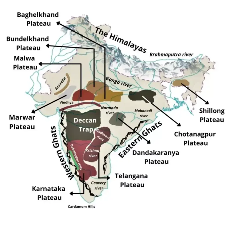
(i) Malwa Plateau-
- This Plateau is formed of lava and covered with black soils.
- The northern part of the plateau has been converted into ravines by River Chambal.
- Betwa, Parvati, Neewaj, Kali Sindh, and Chambal Rivers drain it. The general height decreases from south to the north.
(ii) Bundelkhand and Baghelkhand Plateaus-
- Bundelkhand is the portion of the Central Highlands located east of the Malwa Plateau.
- It is composed of the old Bundelkhand gneiss and stretches between the Gwalior Plateau and Vindhyachal Range.
- The region disappears near the Yamuna Plain to the north.
- Baghelkhand Plateau is located east of the Kaimur and Bharner hills.
- The plateau is made up of sandstones and limestones to the west and granite to the east.
- The central part of the plateau functions as a water divide between the Son drainage system in the north and the Mahanadi river system in the south.
III) Chhotanagpur Plateau-
- It is situated in the east of Baghelkhand, separated by River Son, flowing in north-west and joins the Ganga.
- Mahanadi, Swarn Rekha and Damodar are the other main rivers.
- Damodar River flows through the middle of this region in a rift valley from west to east.
- It has large deposits of Gondwana period.
- Mahanadi forms its southern limit, and flows in south -east direction.
- Raj Mahal Hills form the north eastern edge of the plateau. These are mostly made of basalt
- Hazaribagh, Kodarma and Ranchi are the other main plateaus.
- These plateaus are known as storehouse of minerals. Bauxite, mica, and coal are the ma in minerals, found in abundance.
- Hilly slopes and river valleys are known for rice cultivation
(iv) Meghalaya Plateau-
- It is an extension of the main Peninsular plateau
- The rocks of the Peninsular Plateaus are extended beyond the Rajmahal hills, and form a rectangular block known as Meghalaya or Shillong Plateau. Garo -Rajmahal gap has separated it.
- This gap is the result of down-faulting, which was filled by sediments deposited by the Ganga.
The Meghalaya plateau is further sub-divided into three: A. The Garo Hills;
B. The Khasi Hills;
C.The Jaintia Hills, named after the tribal groups inhabiting this region.
- The Meghalaya plateau is abundant in mineral resources such as coal, iron ore, sillimanite, limestone, and uranium, similar to the Chotanagpur plateau.
- The area experiences heavy rainfall from the southwest monsoon, resulting in a heavily eroded surface.
- Cherrapunji, located in the southern part of the Khasi Hills, has a rocky surface that lacks permanent vegetation cover.
(v) Deccan Plateau-
- The shape of this plateau is triangular
- It is also known as Maharastra Plateau. Much of the region is underlain by basaltic rocks of lava origin.
- Includes the parts of Madhya Pradesh, Chhattisgarh, Maharashtra, and Gujarat.
- River Tapi forms its north limit, the Western Ghats are found in the west. The depth of lava is upto 2000m. This depth declines from west to east.
- The slope is from north-west to south-east. The broad and shallow valleys of the Godavari, the Bhima and Krishna are flanked by flat topped steep sided hills and ridges.
- The entire area is covered by black cotton soil known as regur.
(vi) Telangana Plateau-
It is divided as follows-
A. Hyderabad Plateau.
B. Telangana Peneplain.
C. Godavari Valley.
D.Krishna Valley.
- It covers most part of Telangana state. Godavari River has divided it into two regions, namely the ghats and rolling plains.
- The northern part is of hilly nature and is covered with forests. River Wardha has its flow on it.
- The southern part is peneplain in nature. It has given birth to a number of big towns like Hyderabad and Secundrabad.
(vii) Karnataka Plateau-
It is extended in the south of Maharastra. The 600 m contour line divides it into two parts-
A. The Northern Part-
- It contains the head of the Tungbhadra and Kaveri river. Here Ghat Prabha and Mal Prabha Rivers join Krishna on its right bank.
B. The Southern Part-
- It is known as Mysore Plateau. It is made up primarily of the Archean formations.
The plateau is divided into two parts called Malnad and Maidan.
- The Malnad in Kannada means hill country. It is dissected into deep valleys covered with dense forests.
- The Maidan is formed of rolling plain with low granite hills.
The entire plateau tapers between the Western Ghats and Eastern Ghats in the south and merges with the Nilgiri Hills there.
Hills, Ranges and Mountains of Peninsular Plateau
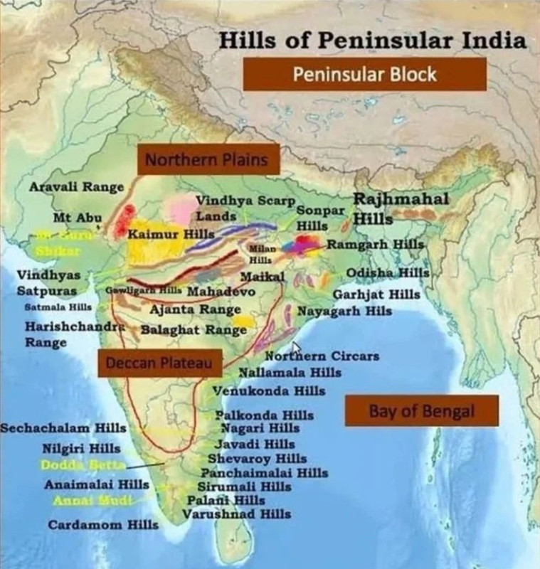
(i) The Vindhyachal Mountain Range-
Structure-
- It is a complex, discontinuous chain of mountain ridges, hill ranges, highlands and plateau escarpments in west-central India.
- The range comprises a mixture of Vindhyachal, Bharner, Kaimur, and Parasnath Hills, and it is made up of sedimentary rocks that are horizontally layered and of considerable antiquity.
Extension
- It extends more or less parallel to the Narmada valley in an east-west direction from Gujarat to Sasaram in Bihar. The total length in 1200 km.
Watershed
- This range acts as a watershed between the Ganga system and the river systems of south India.
- It rather separates North India to South India. The northern slope of this range is rather gentle, but the southern slopes are marked with spurs, steep falls and valleys.
(ii) Satpura Mountain Range-
Introduction
- The Satpura Range is a chain of hills located in central India.
- It starts in eastern Gujarat and runs eastward along the borders of Maharashtra and Madhya Pradesh before ending in Chhattisgarh.
- The name Satpura is derived from the words Sat (seven) and Pura (mountains), as the range is a series of seven mountains.
- It is situated south of the Vindhyas and lies between the Narmada and Tapi rivers, running roughly parallel to them.
- These facts highlight the location, name, and direction of the Satpura Range in a concise and plagiarism-free manner.
- It commences from Rajpipla Hills in the west and further in the east and north -east direction extended through Mahadev and Maikal Hills. In east, it is submerged in Rajmahal Hills.
Horst Mountain
- The Satpura Range is a type of mountain known as a horst, which is located between the Narmada Graben to the north and the Tapi Graben to the south.
Highest Peaks
- The highest peak of this range is Dhupgarh (1350m) near Pachmarhi on Mahadev Hills.
- Amarkantak is the second highest peak with a height of 1066m. Narmada River takes it origin near to the peak. It has number of waterfalls. The main water fall is Dhuandhar on River Narmada near Jabalpur. Marble stone rocks are found here.
The Tapi
- The Tapti River originates in the eastern-central part of Satpura
(iii) Aravalli Hills-
Oldest Mountain Range
- The Aravalli Range is arguably one of the oldest geological features on Earth, having its origin in the Proterozoic era.
- It runs in north-east to south-west direction for a distance of 800 km. between Delhi and Palanpur (Gujarat).
- The range is mostly composed of quartzites, gneisses, and schists of the Pre-Cambrian age.
Extension-
- In the north it is lower than 400m near Delhi. Here, these are known as Delhi Hills (304m). It is supposed to continue further north upto Hardwar buried under the alluvium of the Ganga Plains.
- In the south, it fans out into several ridges, most of them rising to above 900m.
Highest Peak
- The highest point is reached at the Gurusikhar Peak (1722m) in the Abu Hills. Near Udaipur, these are known as Jarga Hills and near Alwar as Harsh Nath Hills.
- This range functions as Water-divide. Mahi and Luni on its west, flows to Arabian Sea.
The Banas
- Banas, a tributary of Chambal, is on its east. All these are seasonal rivers.
(iv) Western Ghats-
Introduction
- The Western Ghats are also known as Sahayadris.
- They are located on the western edge of the Deccan tableland.
- The mountain range runs in a north-south direction, parallel and close to the Arabian Sea Coast for about 1600km.
- The Western Ghats rise abruptly as a sheer wall to an average elevation of 1100m from the Western Coastal Plain, making them an imposing mountain range.
- They slope gently on their eastern flank. They composed of horizontally bedded lavas.
- These ghats have high surface variations.
North Sahyadri
- The north Sahyadri extends from Tapi Rive r to the origin of Malprabha River, with a length of 650km.
- Gadavari, Bhima, Krishna and Ura Rivers are originated from this area.
Middle Sahyadri
- Middle Sahyadri runs between Malprabha River origin and Palghat pass.
- The main peaks are Kudra Mukh (1892m) and Pushpagiri (1714m).
- Tungbhadra and Kaveri Rivers drain this area. Here, Nilgiri Hills mark the junction of the Western Ghats with Eastern Ghats. Doada Betta (2637m) is an important peak of the area.
South Sahyadri
- South Sahyadri is extended from Nilgiri Hills to Kanyakumari upto a distance of 290km. Here, Palghat Gap is a prominent break in its continuity. It gives passage to Tamilnadu from Kerala.
- AnaiMudi (2695m) is the highest peak of South India.
- Palni Hills are in north east and Cardamom Hills are in south.
- Western Ghats present a very youthful topography. The rivers flowing eastward have broad valleys.
Passes
- Thalghat and Bhorghat are two main passes.
- Thalghat is at 581m height and provide passage to Kolkata, while Bhorghat is at 630m height connect Pune with Mumbai.
v) Eastern Ghats-
Introduction-
- These form the eastern boundary of the Deccan Plateau. They are extended from the south of River Mahanadi upto Nilgiri Hills in a length of 1300km. in North -east to south-west direction.
- These Hills have been badly eroded by rivers.
Highest Points
- The highest point (1680m) is in the Visakhapatnam district. Mahendragiri (1501m),the second highest peak, is in the Ganjam district of Odisha.
- The ranges are principally composed of Khondalites and Charnokites and covered with dense forests.
- These hills have been quite disappeared between Godavari and Krishna Rivers deltas. They appear again as continuous ranges in only the Cuddapah and Kurnool districts of Andhra Pradesh.
Different Names
- These ranges, here are known as Nallamalai Hills, 900-100m high, composed of quartzites and slates, the southern part of these hills is called PalKonda Range. Further south in Tamilnadu, these hills become confusing, and have number of ranges in west and south-west direction.
- Javadi Hills in North Arcot district, Gingee Hills in South Arcot district,
- Kollaimalai and Pachaimalai in Tiruchirapalli district,
- Shevroys and Gondumalai in Salem district
- Biligiri Rangan Hills in Coimbatore district, which join Nilgiri Hills.
- Melagiri Range between Kaveri and Pinar Rivers is famous for the sandalwood and teak forests. Here
Other Geomorphic Features:
(i) Narmada Valley-
- It is a rift valley.
- It lies between Vindhyachal Range in the north and Satpura Range in the south.
- It is in the form of structural depression.
(ii) Tapi Valley-
- It is extended in the south of Satpura Ragne.
- Its in the form of rift valley.
(iii) Kathiawar and Kutch Peninsulas-
- It is a bag type peninsula, which has been separated by alluviums of Gujarat from Peninsular Plateau.
- It is mostly composed of Deccan lavas, while tertiary rocks predominate in the Kutch peninsula, which is characterized by small folds, dissected plateaus and scarp lands.
- The northern most part of Kutch peninsul a is known as Rann of Kutch. It is a subsided surfaced covered with mud flats and salt marshes flooded during the rains. The most part of Kathiawar Peninsula is composed by sand dunes.
- The midpoint of this peninsula has Girnar and Gir Hills. The Girnar peak is the highest peak with a height of 1117m.