Air Mass-
- An air mass is defined as a large body of air whose physical properties like temperature, moisture content and lapse rate are more or less uniform horizontally for hundreds of kilometers.
Introduction to Air Mass-
- An air mass develops its characteristics when it stagnates or remains over a uniform land or sea surface long enough to acquire the temperature/ humidity / stability characteristics of the surface below.
Following conditions are essential for the development of an air mass-
-
An extensive area of land or water characterized by uniform temperature and humidity conditions.
-
A stationary, extensive body of air over a surface without any divergent winds is known as an anticyclone.
- Prevailing calm conditions and preferably high pressure conditions.
Origin of an Air Mass-
Source Regions-
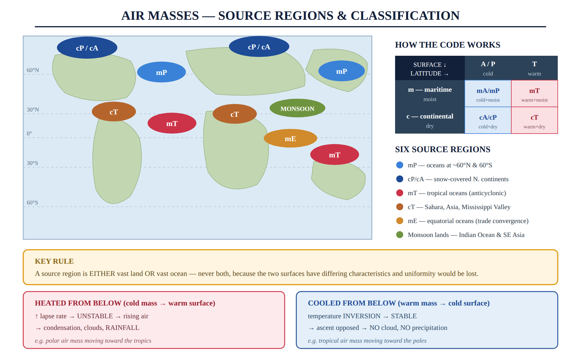
- A source region is an extensive land or ocean area where there is a significant similarity in essential features such as temperature and humidity.
- The most suitable source regions for meteorological air masses are characterized by a uniform surface, which includes the ocean surfaces and flat land areas with consistent coverings of snow, forests, or deserts.
- A source region may comprise of either vast stretches of land or ocean.
- But it never comprises of both types of surfaces since both surfaces have differing characteristics and a source region always exhibits uniform character stretching over thousands of kilometers.
Following are the main source regions-
1.Polar Oceanic Areas/Maritime Polar(mP)-
- The maritime polar air masses are located over the oceans at approximately 60°North and 60°South.
- The northern part of the Atlantic Ocean and the eastern part of the Pacific Ocean provide suitable conditions for air mass formation.
2.Polar and Arctic Continental Areas(cP)-
- The northern parts of the continents in the northern hemisphere are located near the Arctic region and experience continuous snow and ice cover. Due to their extreme cold temperatures, these areas are characterized by cyclonic weather conditions.
- As such this source region offers good opportunities for air mass formation.
3.Tropical Oceanic Areas or Maririme tropical (mT)-
- These source regions are found over oceans in the tropical zone and these are the areas experiencing anticyclonic conditions for entire year.
4.Tropical Continental Areas(cT)-
- They are located in North Africa (Sahara, Asia, Mississippi Valley of USA).
5.Maritime Equatorial Regions(mE)-
- Trade winds from the north and the south converge over the oceans at the equator and give rise to maritime equatorial sources region.
6.Monsoon Lands -
- It is located in Indian ocean and S.E. Asia.
Air Mass Classification-
Classification on the basis of source of origin-
- mA: maritime Arctic type.
- cA: continental Arctic.
- cP: continental Polar.
- cT: continental Tropical.
- mP: maritime Polar.
- mT: maritime Tropical.
Classification of the basis of Temperature-
- There are Two types of Air masses Cold air mass and Warm Air mass.
- When cold air masses move, they undercut the warmer air masses due to their higher density. This forces the warmer air to rise up and over the colder air, causing it to ascend into the atmosphere.
Modifications of Air Masses-
As air masses are not stationary therefore they comes in contact of different temperature,pressure etc. Which leads to its modification.
1. Thermodynamic Modifications-
- Modification of an air mass resulting from the transfer of heat between the bottom of an air mass and the surface over which it moves is known as thermodynamic modification.
A. When air mass is heated from below-
- If an air mass moves over a surface that has a higher temperature than the air mass itself, the lower layers of the air mass will experience warming.
- This results in increased lapse rate and instability conditions.
- This situation promotes the rise of warm lower air, which may lead to condensation, cloud formation, and rainfall.
Example- A polar air mass moving towards the tropical zone.
B. When air mass is cooled from below-
- When an air mass moves over a surface which is colder than the lower layer of the air mass, there is a chilling of the surface air and inversion of temperature takes place.
- This situation Increases the stability of the air which is opposed to the ascent of air.
- Under such conditions, formation of the clouds and precipitation is not possible.
Example- A tropical air mass moving towards the polar region.
2. Mechanical modification-
- This types of modification happens due to cyclones, anticyclones, surface friction or due to meeting of different air masses.
- It also occurs due to Turbulent mixing caused by eddies or convection ,Large-scale dynamic effects on in lapse rate; divergence and convergence.
Fronts-
A front is a meteorological term used to describe the boundary between two air masses with different temperatures, densities, and moisture content, resulting in distinct weather patterns.
Types of Fronts-
It is of following types-
1. Cold Fronts
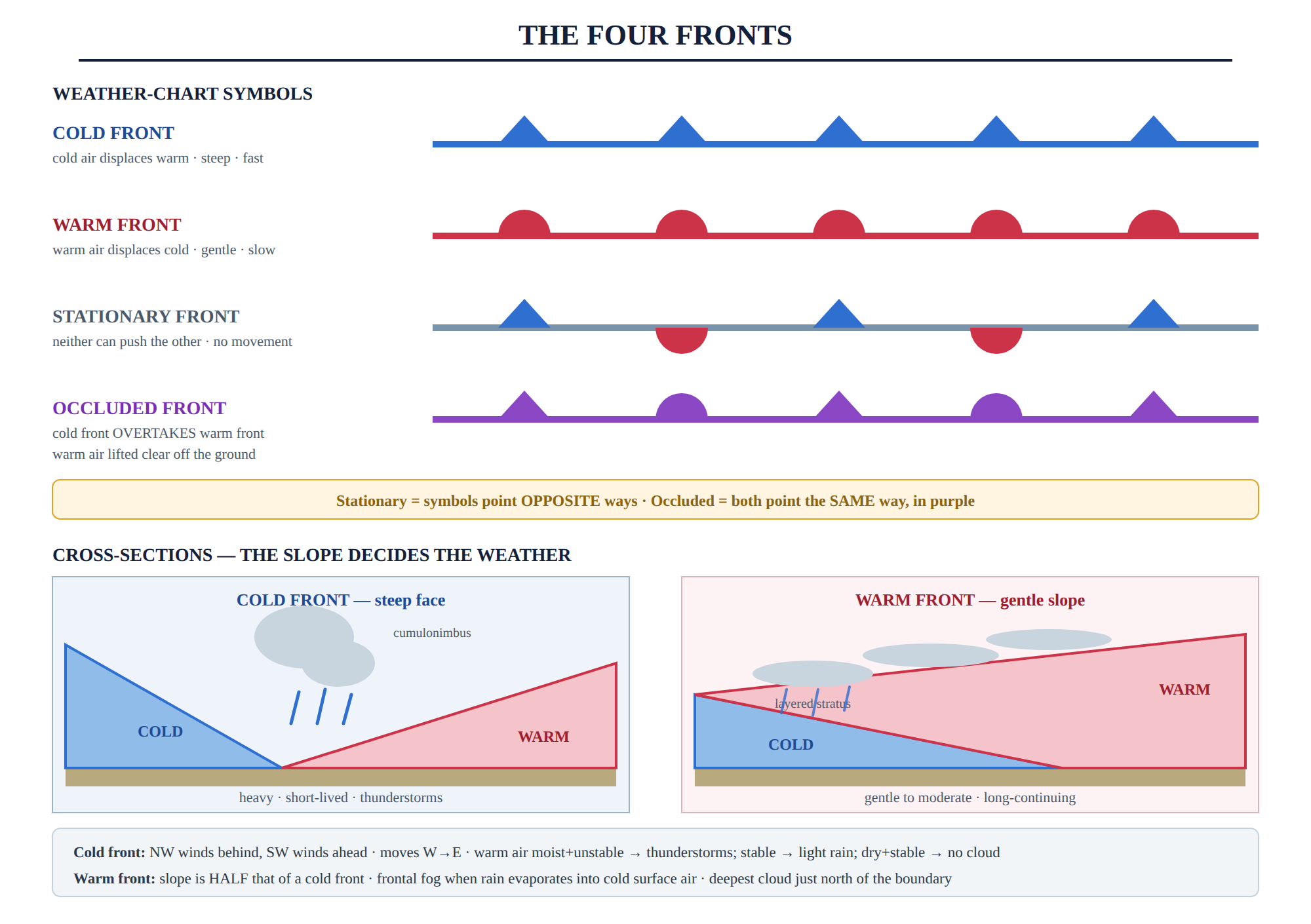
- Cold fronts form when cold air dis places warm air.
- They are Indicative of heavy precipitation events, rainfall or snow, combined with rapid temperature drops.
- They have steep front slope and moves faster.
- There is northwesterly winds behind a cold front, and southwesterly in ahead of it.
Weather associated with it-
-
Thunderstorms and other severe weather events are commonly associated with cold fronts.
- They usually move from west to east.
- The type of precipitation that will occur along a cold front depends on the characteristics of the warm air ahead of characteristics of the warm air ahead of the front.
- If the warm air is moist and conditionally unstable than thunderstorms can be there.
- If the warm air is stable, the clouds that form by lifting only produce light rain.
- If the warm air is dry and stable no clouds will form at all.
- Formation of thick Cumulonimbus Clouds are also there.
2. Warm Fronts-
- A warm front marks the boundary between a moving warm air mass and a receding cold air mass.
- They are created when warm air displaces colder air.
- Slope of these fronts is half of slope of cold fronts.
- They forms shallow horizontal stratus clouds and light precipitation.
- Frontal fog can occur when raindrops fall into colder air near the surface and evaporate.
- Warm fronts move more slowly than cold fronts because it is more difficult for the warm air to push the cold, dense air across the Earth's surface.
Warm Front Weather-
- Warm fronts can often result in stormy weather because the warm air mass present at the surface rises above the cool air mass, creating clouds and ultimately leading to the formation of storms.
- Clouds located north of the warm front boundary are the deepest, gradually thinning and rising as you move further north.
- If the warm air is conditionally unstable thunderstorms may develop over the warm front.
- If the warm air is stable, the clouds will be layered.
- Gentle to moderate precipitation which continues for a long time may occur in this front.
3. Stationary Fronts-
- When a frontal system stops moving forward, a stationary front occurs.
- When a stationary front starts to move again, it may be either a warm front or a cold one.
- The cold air on the north side of the front is moving parallel to the front, while the warm air to the south moving toward the front and get lifted along the frontal boundary.
- It forms when two contrasting air masses come face to face but neither of them is able to push the other so there is no displacement or upward movement of the air and no competition for dominance exits.
4. Occluded Fronts-
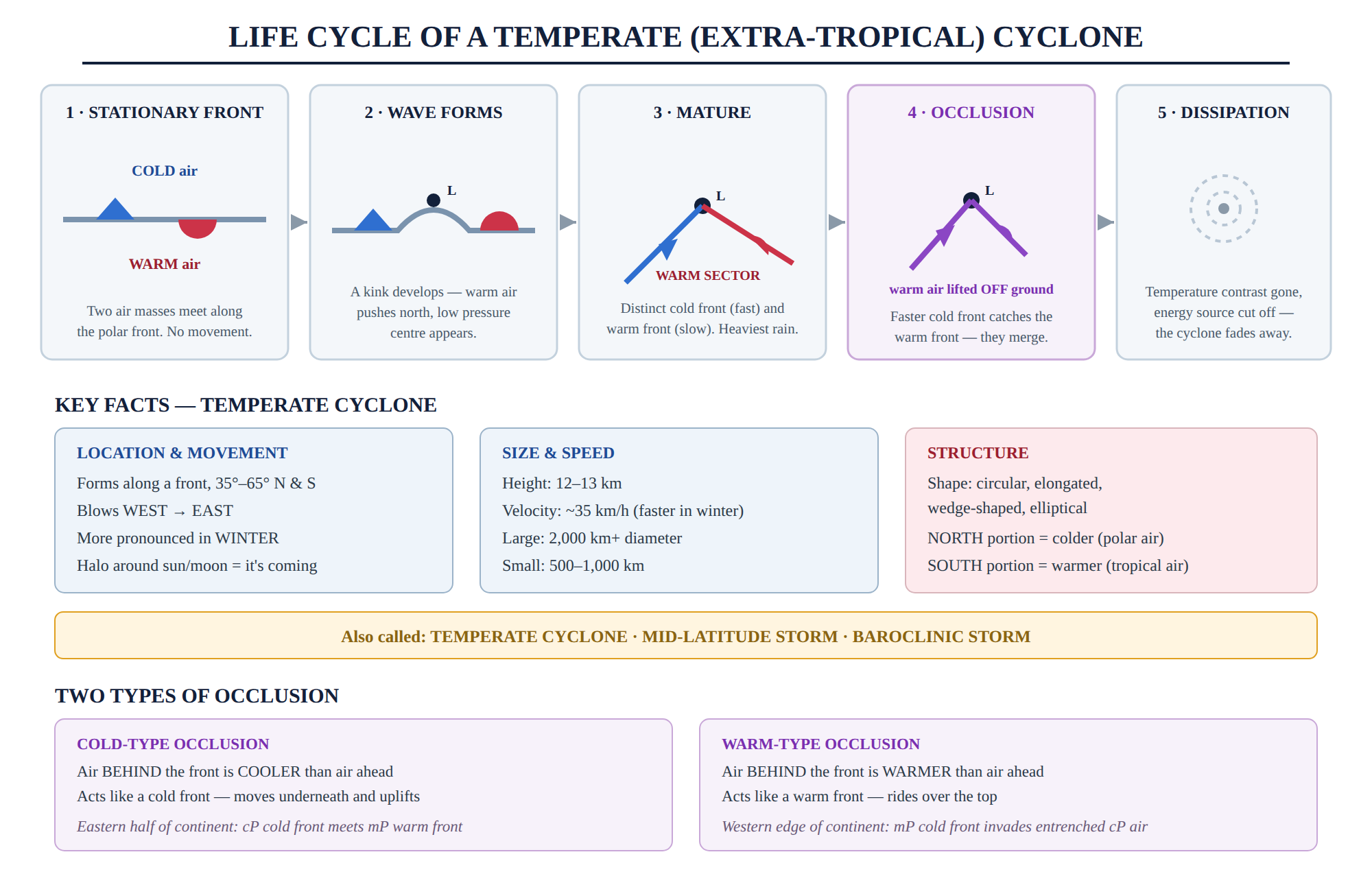
- An occluded front specifically forms when the faster cold front overtakes the warm front, lifting the warm air entirely off the ground
- Occlusion takes place when a mass of warm air is pushed upward and removed from the ground by dense mass of cold air.
- There are two types of occlusion cold front type and warm front type.
A cold-type occlusion:
- A cold occlusion is a weather phenomenon that takes place when the air located behind the occluded front is cooler than the air situated in front of it.
- A cold occlusion functions in a similar manner to a cold front, as the colder air situated behind the occlusion moves underneath and uplifts the air in front of it.
- It takes place in eastern half of the continent where a cold front associated with cP air meets a warm front with mP air ahead.
A warm -type occlusion -
- In this type the cold air behind the occluded front is warmer than the air ahead of it.
- It acts in a similar way to a warm front.
- The cold air behind the front is less dense than the even colder air ahead of it, and so it passes over the top of the colder air.
- It occurs in the western edges of continents where the cold front, associated with mP air, invades an area in which colder cP air is entrenched.
Weather associated with Occluded Front-
- Due to presence of both cold and warm front there is mixed weather condition.
Cyclones-
- A cyclone is a weather phenomenon characterized by a large air mass that rotates around a center of low atmospheric pressure.
- The direction of cyclones is opposite in the Northern Hemisphere and Southern Hemisphere. In the Northern Hemisphere, the direction is counterclockwise, while in the Southern Hemisphere, it is clockwise. This is due to the Coriolis effect, which causes the rotation of the earth to influence the direction of winds and currents.
- Closed isobars surround the low pressure and there is movement of air inward from the outer high pressure zone to the inner low pressure zone.
Types of Cyclones
(i) Extra Tropical Cyclones:
- These types of cyclones are known as Temperate cyclones.
- They are formed along a front in mid-latitudes between 35° and 65° N and S.
- They blow from west to east and are more pronounced in winter season.
- Formation of halos around the sun/moon results with the arrival of temperate cyclones.
Characteristics of Extra Tropical Cyclones-
Shape-
- They are circular, elongated, wedge shaped and elliptical.
Height -
- It can be upto 12-13 k.m.
Movement -
- In general they have an easterly pattern of movement and in general the warm and moist tropical air has a westerly direction of flow.
- Whereas, the cold and dry polar air has an easterly direction of flow.
Velocity-
- They have approximately average velocity of 35 k.m. and their velocity increases in Winters and decreases in Summers.
Area -
- A large cyclone can have a diameter of about 2000 km or more and the diameter of a small cyclone may range between 500 km - 1000 km.
Temperature -
- The northern portion records a lower temperature due to presence of cold polar air in that portion and vice-versa for the southern portion due to presence of warm tropical air.
Path-
- They can be tracked easily due to slow movement.
Extra-tropical cyclones are also known as mid-latitude storms or baroclinic storms.
Tropical Cyclones
Definition
A tropical cyclone is a violent, rapidly rotating storm system that originates over warm tropical oceans, characterised by a low-pressure centre, strong winds, and a spiral arrangement of thunderstorms producing heavy rainfall.
- Thermally induced and non-frontal in nature (i.e., no fronts are involved unlike temperate cyclones).
- Derive their entire energy from the latent heat released when water vapour, evaporated from the warm sea surface, condenses inside the storm.
- Rapidly weaken after landfall because the supply of moisture from the ocean gets cut off.
Conditions Necessary for the Formation of Tropical Cyclones
1. Large Sea Surface with High Temperature
- Sea surface temperature should be more than 26.5°C.
- Warm water should extend up to a depth of about 50–60 metres.
- This warm water acts as the fuel of the storm by supplying moisture and heat energy.
2. Presence of Coriolis Force
- The system must be located at least 5° away from the equator.
- Coriolis force is zero at the equator; therefore, the storm cannot start rotating there.
- Hence, tropical cyclones never form in the 0°–5° belt on either side of the equator.
3. Small Variation in Vertical Wind Speed (Low Vertical Wind Shear)
- There should be very little difference in wind speed with increasing height.
- Strong wind shear tears apart the growing storm before it can organise itself.
4. Pre-existing Weak Low Pressure Area
- A weak low-pressure area or a pre-existing tropical disturbance must already be present.
- It acts as the seed of the cyclone.
5. Upper Level Divergence
- Air must flow out at the upper levels of the atmosphere.
- Removal of air from the top keeps the surface pressure falling, allowing the cyclone to intensify.
6. High Humidity in the Middle Troposphere
- The middle layers of the atmosphere should be moist.
- If dry air intrudes at mid-levels, it suppresses convection and kills the storm.
???? Note: All these conditions must be present together. If even one condition is absent, the cyclone cannot develop.
The Energy Engine of a Tropical Cyclone-
Warm sea evaporates water -> Water vapour rises in the low pressure area -> Vapour condenses and releases LATENT HEAT -> Air warms further and rises faster -> Surface pressure falls -> Storm intensifies further
This is a self feeding cycle and it continues as long as the cyclone remains over warm ocean water.
Structure of a Tropical Cyclone
1. Eye
- Centre of the cyclone.
- Diameter: 10–50 km.
- Air subsides (sinks).
- Calm and almost cloud-free.
- Records the lowest pressure of the storm.
Important: Many people think the storm is over when the eye passes, but the second half of the storm is still to come.
2. Eye Wall
- Ring of towering Cumulonimbus clouds surrounding the eye.
- Region of:
- Strongest winds
- Heaviest rainfall
- Most destructive part of the cyclone.
3. Spiral Rain Bands
- Curved bands of thunderstorms spiralling inward.
- Feed moisture into the cyclone.
Size and Height
| Feature | Value |
|---|---|
| Diameter | 150–1000 km |
| Height | 12–15 km |
Direction of Rotation
| Hemisphere | Rotation |
|---|---|
| Northern Hemisphere | Counterclockwise ↺ |
| Southern Hemisphere | Clockwise ↻ |
(Due to Coriolis Force)
Why do Tropical Cyclones Weaken After Landfall?
Two major reasons:
1. Loss of Moisture Supply
- Warm ocean no longer supplies moisture.
- Latent heat—the main energy source—is cut off.
2. Increased Surface Friction
- Land surface is much rougher than the ocean.
- Friction rapidly disrupts the circulation of the storm.
Result: The cyclone weakens and dissipates quickly after landfall.
Storm Surge
A storm surge is the abnormal rise of sea water pushed towards the coast by:
- Strong cyclonic winds.
- Low pressure at the centre of the cyclone.
It is usually the deadliest element of a tropical cyclone, causing more deaths than the wind itself.
Regional Names of Tropical Cyclones
| Region | Name |
|---|---|
| Indian Ocean & Bay of Bengal | Cyclone |
| Atlantic Ocean & Eastern Pacific | Hurricane |
| Western Pacific & China Sea | Typhoon |
| Australia | Willy-willies |
| Philippines | Baguio |
| Japan | Taifu |
Classification of Cyclones by IMD (North Indian Ocean)
The India Meteorological Department (IMD) classifies low-pressure systems over the Bay of Bengal and the Arabian Sea on the basis of maximum sustained wind speed as adopted by W.M.O.
| Type of Disturbance | Maximum Sustained Wind (km/h) |
|---|---|
| Low Pressure Area | Not exceeding 31 |
| Depression (D) | 31–49 |
| Deep Depression (DD) | 50–61 |
| Cyclonic Storm (CS) | 62–88 |
| Severe Cyclonic Storm (SCS) | 89–117 |
| Very Severe Cyclonic Storm (VSCS) | 118–167 |
| Extremely Severe Cyclonic Storm (ESCS) | 168–221 |
| Super Cyclonic Storm (SuCS) | 222 and above |
Important Points
- IMD assigns a name to the system once it reaches the Cyclonic Storm stage (62 km/h).
- IMD uses a 3-minute mean sustained wind.
- US agencies use a 1-minute mean sustained wind.
- Therefore, the same cyclone may have different reported wind speeds by different agencies.
Difference Between Tropical Cyclone and Temperate Cyclone
| Basis | Tropical Cyclone | Temperate Cyclone |
|---|---|---|
| Location | Tropics (5°–30° N & S) | Mid-latitudes (35°–65° N & S) |
| Fronts | No fronts; uniform air mass | Forms along fronts; two air masses required |
| Energy Source | Latent heat from warm ocean water | Temperature contrast across the front (Baroclinic energy) |
| Season | Late summer & autumn | More pronounced in winter |
| Direction of Travel | East → West (Trade Winds) | West → East (Westerlies) |
| Size (Diameter) | 150–1000 km | 500–2000 km or more |
| Wind Speed | Very high; can exceed 200 km/h | Moderate; around 35 km/h (average) |
| Duration | Few days; weakens rapidly after landfall | Can persist for weeks |
| Eye | Present | Absent |
| Rainfall | Torrential and concentrated near the centre | Gentle to moderate; spread over a wide area |
| Path | Erratic and difficult to forecast | Regular and easier to track |
| Occurs Over | Sea only; dies over land | Both land and sea |
Important One Liner On Air Mass and Fronts.
What is an air mass?
A large body of air with uniform temperature, moisture, and lapse rate.
How does an air mass develop its characteristics?
By stagnating over a uniform land or sea surface long enough.
What conditions are essential for air mass development?
Prevailing calm conditions and preferably high pressure conditions.
What is a source region?
An extensive land or ocean area with uniform features.
What are the most suitable source regions for air masses?
Areas with consistent coverings of snow, forests, or deserts.
What are the main source regions for air masses?
Polar Oceanic, Polar and Arctic Continental, Tropical Oceanic, Tropical Continental, Maritime Equatorial, and Monsoon Lands.
How many types of air masses are there based on their source of origin?
Six: mA, cA, cP, cT, mP, and mT.
What are the two types of air masses based on temperature?
Cold and warm.
What happens when cold air masses move?
They undercut the warmer air masses and cause them to rise.
What are the two types of modifications of air masses?
Thermodynamic and mechanical.
What is thermodynamic modification?
The transfer of heat between the bottom of an air mass and the surface over which it moves.
What happens when an air mass is heated from below?
Increased lapse rate and instability conditions, leading to cloud formation and rainfall.
What happens when an air mass is cooled from below?
Increased stability and opposition to the ascent of air, making cloud formation and precipitation impossible.
What is mechanical modification?
Modifications due to cyclones, anticyclones, surface friction, or the meeting of different air masses.
What are fronts?
The boundary between two air masses with different temperatures, densities, and moisture content.
What are the types of fronts?
Cold fronts, warm fronts, stationary fronts, and occluded fronts.
What is a cold front?
A front formed when cold air displaces warm air, indicative of heavy precipitation events.
What is a warm front?
A front formed when warm air displaces cold air, characterized by gentle, prolonged precipitation.
What is a stationary front?
A front that remains in one place, with the air masses on either side not advancing.
What is an occluded front?
A front that occurs when a cold front catches up to and overtakes a warm front.