The term Monsoon has its origin from the Arabic word Mausim or Malayan word Monsoon, which means ‘season.
Theories of origin of monsoon
These theories are classified into TWO broad groups
1.Classical Theory
2.Modern Theories
1.Classical Theory
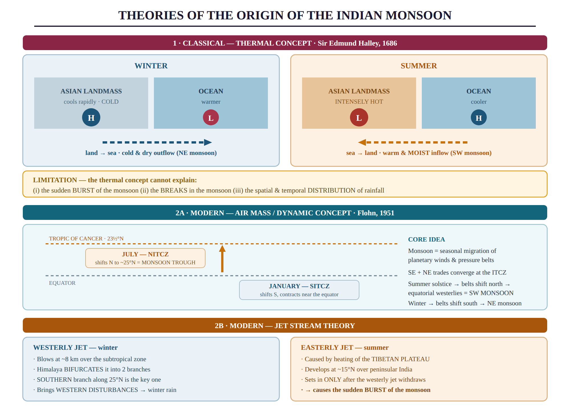
A. Thermal concept of Sir Edmund Hailey
- The thermal concept of Sir Edmund Hailey was proposed in 1686.
- Hailey's concept explains the monsoon as resulting from differential heating of continents and oceans, leading to thermal contrasts.
- Monsoons are essentially extended land breeze and sea breeze on a large scale.
- During winter, the huge landmass of Asia cools more rapidly than the surrounding oceans, resulting in the development of a strong high-pressure center over the continent.
- On the other hand, the pressure over adjacent oceans is relatively lower, leading to a pressure gradient directed from land to sea. This causes an outflow of air from the continental landmass towards the adjacent oceans, bringing cold and dry air towards low latitudes.
- In summer, the temperature and pressure conditions are reversed.
- However, the thermal concept fails to explain sudden bursts of monsoon, breaks in monsoon, and the spatial and temporal distribution of monsoon .
2. Modern concepts
A. The Air Mass Concept (Dynamic theory)
- Flohn developed this dynamic concept in 1951.
- The southeast trade winds in the southern hemisphere and northeast trade winds in the northern hemisphere converge at the Inter-Tropical Convergence Zone (ITCZ).
- During the summer solstice, the sun's rays fall vertically over the Tropic of Cancer, causing pressure and wind belts to shift northwards.
- As a result, the Inter-Tropical Convergence (ITC) moves northward, and the Indian landmass is impacted by the equatorial westerlies, known as the south-west monsoon.
- During the winter season, the pressure and wind shift southward, thereby establishing the north -east monsoon over this region. Such systematic change in the direction of planetary winds is known as monsoon.
- The north -ward migration of this ITC is an important factor influencing particularly the onset and intensity of south-west monsoons.
- Monsoon trough - The ITC shifts northward in summer season and has its position on north part of India. It’s shifting towards north on the increase in temperature. This ITC is sometimes called as monsoon trough. It leaves its influence on the distribution of rainfall and also on the route of monsoon cyclones.
- ITC changes its position in winter season. It is shifted towards the Equator. North India comes in the influence of North -East trade winds. When these winds cross Bay of Bengal gain moisture, and thus provide rains to Eastern Coastal areas.
- The ITC is contracted, when it reaches near to Equator. In real sense, this ITC is a zone of low pressure separating the north-east winds with the south-east trade winds. The position and presence of this zone affect the direction and amount of rainfall mainly in summer season.
- The seasonal shift of the ITCZ has given the concept of Northern Inter- Tropical Convergence Zone (NITCZ) in summer (July) and Southern Inter-Tropical Convergence Zone (SITCZ) in winter (Jan.)
B. Jet Stream Theory:
- This concept is based on the role of Jet Streams, Tibet Plateau, and the ocean bodies in explaining the origin monsoon
- Jet Stream- These are circum-polar air currents. These winds flow in both the hemispheres between winter 20 0N-350C in northern hemisphere and summer the surface
- Jet streams are upper air circulation winds and blow just like an ocean current. The meandering narrow and strong speedy air current of Upper Troposphere are known as Jet Streams. They change their location according to season.
- They shift towards near Equator in winter season and towards poles in summer season.They blow from west to east in westerlies belt.
- Their speed is high in the central part than the sides.
(a) Westerly Jet stream and its Impact-
- During Winter, a high-speed westerly jet stream blows over the subtropical zone at about 8 km above sea level.
- The Himalayan ranges bifurcate this jet stream into a northern and a southern branch.
- The northern branch flows along the northern edge of the Himalayas, while the southern branch blows eastwards along 25° N latitude, south of the Himalayas.
- Meteorologists believe that the southern branch of the jet stream has a significant impact on the winter weather conditions over India.
- The southern branch of the jet stream brings western disturbances from the Mediterranean region into the Indian sub-continent.
- These disturbances cause winter rain and hail storms in northwestern plains and occasional heavy snowfall in hilly regions.
(b) Easterly Jet and its Influence
- In summer, the sun shifts towards the northern hemisphere, causing a reversal in upper air circulation.
- The westerly stream is replaced by easterly jet stream, which is caused by the heating of the Tibetan plateau.
- An easterly cold jet stream develops around 15°N latitude and blows over peninsular India.
- This easterly jet stream contributes to the sudden onset of monsoons.
Other concepts that affect monsoon
1. Heating of Tibetan pleated & easterly jet stream
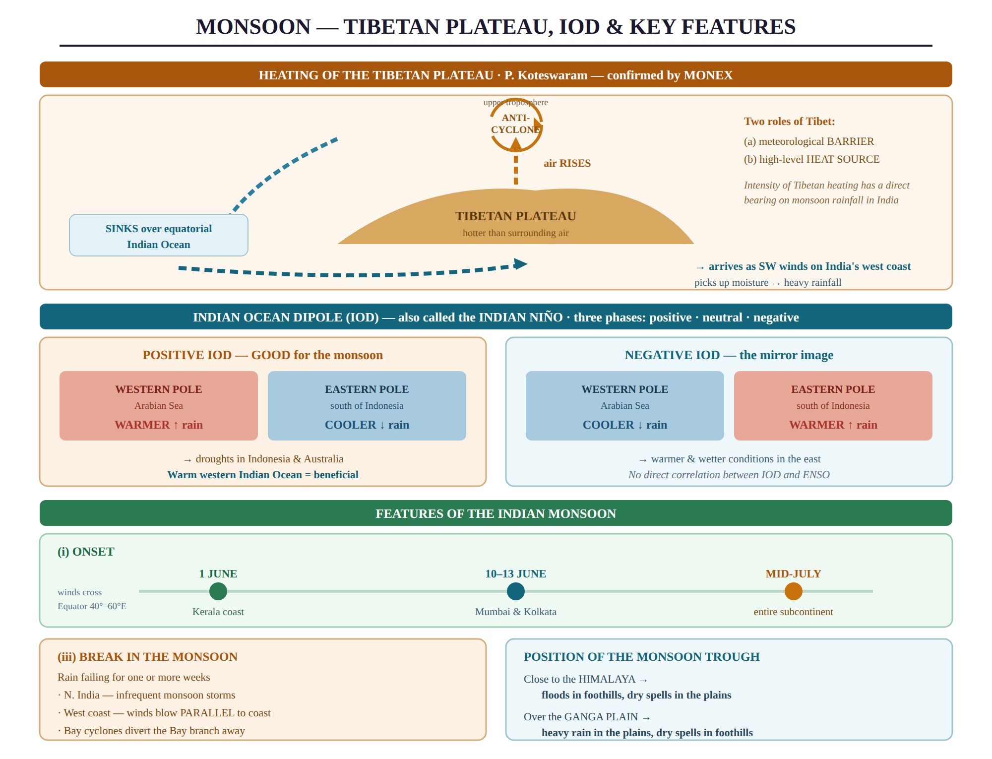
- This concept was given by P. Koteswaram
- He emphasized that Tibet Plateau affects the atmosphere in two ways:
(a) as a meteorological barrier, and
(b) as a high-level heat sources
- Tibet Plateau becomes hot in summer and is warmer than the air over the adjoining regions. It generates an area of rising air. During its ascent, the air spreads outwards and gradually sinks over the equatorial part of the Indian Ocean.
- At this stage, the ascending air is deflected to the right by the earth’s rotation and moves in an anti-clockwise direction leading to anti-cyclonic conditions in the upper troposphere over Tibet.
- When these winds approach the west coast of India, they form south-west direction. After gaining the moisture from the Indian Ocean causes heavy rainfall in India and adjoining countries.
- Thus, it is revealed that intensity and heating of Tibet Plateau has a direct bearing on the amount of rainfall in India by the monsoons.
MONEX-It means Monsoon expedition It is a joint venture of Indian and Russia meteorologists. It has confirmed the views expressed by Koteswaram
2.ROLE OF EL-NINO & LA NINO (already discussed)
3.Indian Ocean Dipole
- The Indian Ocean Dipole (IOD), also known as the Indian Nino, is a phenomenon in the Indian Ocean that involves both the ocean and atmosphere.
- It is identified by the difference in sea surface temperature between two areas, namely the western pole in the Arabian Sea and the eastern pole in the eastern Indian Ocean south of Indonesia.
- The IOD experiences periodic oscillations of sea surface temperatures in three phases - positive, neutral, and negative.
- During the positive phase, there are warmer-than-average sea surface temperatures and increased precipitation in the western Indian Ocean region, with cooler waters in the east that tend to cause droughts in Indonesia and Australia.
- In contrast, the negative phase of the IOD has cooler sea surface temperatures and less precipitation in the western Indian Ocean, with warmer and wetter conditions in the east.
- A positive IOD, which has warm sea surface temperatures in the western Indian Ocean, is beneficial for monsoon.
- There is no direct correlation between the IOD and ENSO.
Features of Indian Monsoon
(i) The onset of the monsoon.
(ii) distribution of monsoon rainfall.
(iii) Break in the monsoon
(i) The onset of the monsoon
- During April and May, when the Tropic of Cancer receives vertical sunlight, the landmass in the northern part of the Indian Ocean gets intensely heated.
- This results in the formation of a strong low-pressure system in the northwest region of the Indian subcontinent.
- As the Indian Ocean in the south of the landmass is slowly heated, it has high pressure, causing the low-pressure cell to attract southeast trades that cross the Equator.
- These conditions shift the position of the ITCZ northward, making the southwest monsoon a continuation of the southeast trades that are deflected towards the Indian subcontinent.
- The winds cross the Equator between 40°E and 60°E longitudes and are linked to the withdrawal of the westerly jet stream from its position over the north Indian plain, south of the Himalayas.
- The easterly jet stream sets in at 15°N latitude only after the western jet stream has withdrawn from the region, and it is responsible for the burst of the monsoon in India.
- The southwest monsoon arrives at the Kerala coast by June 1st and quickly moves to reach Mumbai and Kolkata between June 10th and 13th. By mid-July, it covers the entire subcontinent.
(ii) Distribution of monsoon rainfall
- India experiences two main rain-bearing systems.
- The first system originates in the Bay of Bengal and results in rainfall over the plains of North India.
- The second system is the Arabian Sea current of the southwest monsoon, which brings rain to the west coast of India.
- The Western Ghats region receives a significant amount of rainfall, which is mostly orographic in nature.
- This occurs as the moist air is blocked and has to rise along the Ghats.
The intensity of rainfall over the west coast of India is, however, related to two factors:
(i) The offshore meteorological conditions.
(ii) The position of the equatorial jet stream along the eastern coast of Africa.
The occurrence rate of tropical depressions that originate from the Bay of Bengal fluctuates annually.
Additionally, rainfall that arrives in bursts demonstrates a decreasing pattern from west to east along the west coast and from the southeast to the northwest over the North Indian Plain and the northern region of the Peninsula.
(iii) Break in the monsoon
During the south-west monsoon period, if rain fails to occur for one or more weeks, it is known as break in the monsoon.
These breaks in the different regions are due to different reasons:
(i) Northern India experiences rainfall shortages when monsoon storms are infrequent along the monsoon trough or the ITCZ.
(ii) Along the west coast, dry spells occur when winds blow parallel to the coastline.
(iii) Cyclonic originating head of BoB and their crossing into the mainland may result in BoB branch of SW monsoon winds getting drawn into cyclonic depression resulting in dry spells in SE parts of Ganga plains.
- Position of ITCZ over Northern plain, called as monsoon trough determines tracks of tropical depressions.
- If the trough lies close to Himalayas It causes heavy rainfall in the foothills which results in widespread floods and prolonged dry spells in the plains.
- If the LP trough lies over Ganga plain, it results in heavy rains in the plains and dry spells in the foothills