1. What are Ocean Currents?
● Definition: Ocean currents are the continuous, predictable, directional movement of seawater. They are a massive, large-scale movement of ocean water that is caused and influenced by a combination of forces (insolation, wind, gravity, the Coriolis force, and density differences arising from salinity and temperature).
● Because a current is 'predictable' and 'directional', sailors, fishermen and shipping companies have historically been able to chart and rely on these pathways for centuries — this is part of why currents matter so much for navigation, covered later in this note.
● Ocean water, in fact, moves in two distinct directions, and it is important not to confuse the two:
○ Horizontal movement of water — this is referred to as Currents. This is the lateral, sideways flow of water across the ocean's surface or at depth, and is what this note primarily deals with.
○ Vertical movement of water — this is referred to as Upwelling (rising of water) or Downwelling (sinking of water). Vertical movement is triggered mainly by density differences (cold/saline water is denser and sinks; warm/less-saline water is lighter and rises) and plays a crucial role in nutrient cycling
2. Types of Ocean Currents
Ocean currents can be classified using two different criteria — depth (how far below the surface the current operates) and temperature (whether it carries warm or cold water relative to its surroundings). Both classifications are commonly asked about together, so it helps to master both frameworks side by side.
2.1 Based on Depth
● (a) Surface Currents:
○ These currents occur in the upper 400 metres of the ocean and constitute only about 10% of the ocean's total water volume.
○ They are driven primarily by global wind systems, which are themselves powered by solar energy — so ultimately, surface currents trace back to the Sun's heating of the atmosphere.
○ By transporting warm water from the tropics toward the poles (and cold water back toward the tropics), surface currents play a critical role in moderating both local coastal climates and the global climate system.
○ Examples: Gulf Stream (Atlantic Ocean), Kuroshio Current (Pacific Ocean), Agulhas Current (Indian Ocean).
● (b) Deep Water Currents:
○ The remaining 90% of ocean water is influenced not by wind but by changes in water density arising from variations in temperature and salinity — this process is known as Thermohaline Circulation ('thermo' = temperature, 'haline' = salinity).
○ These currents are generated when dense, cold water sinks into deep ocean basins — a process most pronounced in high-latitude (polar) regions where surface water is coldest and often most saline.
○ The sinking of this dense water sets in motion a global 'conveyor belt' — a single, vast, interconnected system linking surface and deep currents across every ocean basin on Earth.
○ This conveyor belt circulates over the course of thousands of years (a single loop can take roughly 1,000 years), and in doing so it plays a decisive role in long-term climate stability and in the cycling of carbon dioxide and nutrients throughout the world's oceans.
○ Examples: North Atlantic Deep Water (NADW), Antarctic Bottom Water (AABW).
|
Basis |
Surface Currents |
Deep Water Currents |
|
% of ocean water |
~10% |
~90% |
|
Depth |
Upper 400 m of the ocean |
Deep ocean basins |
|
Driven by |
Global wind systems, powered by solar energy |
Density variations (temperature + salinity) — Thermohaline Circulation |
|
Mechanism |
Wind drags surface water in its direction |
Dense, cold, saline water sinks at high latitudes, forming a global 'conveyor belt' |
|
Role |
Moderates local & global climate by moving warm water poleward |
Circulates over ~1,000s of years; affects climate stability, CO2 and nutrient cycles |
|
Examples |
Gulf Stream (Atlantic), Kuroshio (Pacific), Agulhas Current (Indian Ocean) |
North Atlantic Deep Water (NADW), Antarctic Bottom Water (AABW) |
2.2 Based on Temperature
● (a) Cold Currents:
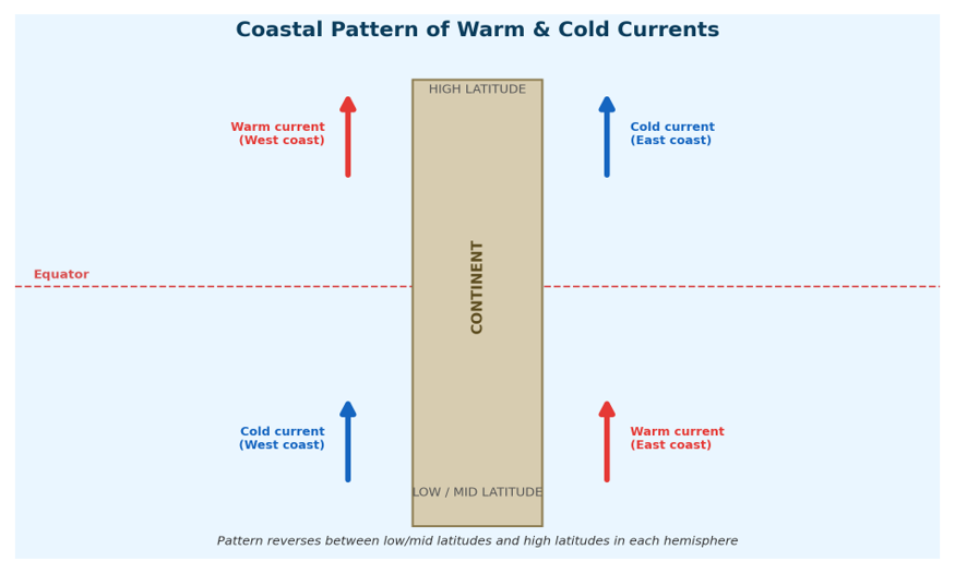
○ Cold currents carry cooler water into warmer regions — i.e., they move from high latitudes toward low latitudes.
○ They are typically found along the western coastlines of continents in the low and middle latitudes, and along the eastern coastlines at higher latitudes.
○ These currents help moderate temperatures in coastal regions (keeping them cooler than they would otherwise be) and contribute to nutrient upwelling, which supports rich marine ecosystems and fisheries.
○ Examples: Kurile or Oyashio Current (North Pacific Ocean), California Current (Pacific Ocean), Labrador Current, Benguela Current, Canary Current.
● (b) Warm Currents:
○ Warm currents transport warm water into colder areas — i.e., they move from low latitudes toward high latitudes.
○ They are usually found along the eastern coastlines of continents in the lower and middle latitudes, as well as along the western coastlines in the Northern Hemisphere at higher latitudes.
○ Warm currents significantly affect coastal climates, often resulting in milder winters and increased rainfall along the coasts they touch.
○ Examples: Gulf Stream (North Atlantic Ocean), Antilles Current (North Atlantic Ocean), Kuroshio, North Atlantic Drift.
|
Basis |
Cold Currents |
Warm Currents |
|
Direction of flow |
High latitude → Low latitude (cool water into warm regions) |
Low latitude → High latitude (warm water into cold regions) |
|
Typical location |
Western coasts of continents (low–mid latitudes); Eastern coasts at higher latitudes |
Eastern coasts of continents (low–mid latitudes); Western coasts in N. Hemisphere at higher latitudes |
|
Effect |
Moderates coastal temperature; causes nutrient upwelling supporting marine life |
Brings milder / warmer weather to coasts; increases rainfall |
|
Examples |
Kurile/Oyashio, California Current, Labrador Current, Benguela, Canary Current |
Gulf Stream, Antilles Current, Kuroshio, North Atlantic Drift |
3. Forces Responsible for the Origin of Ocean Currents
3.1 Primary Forces
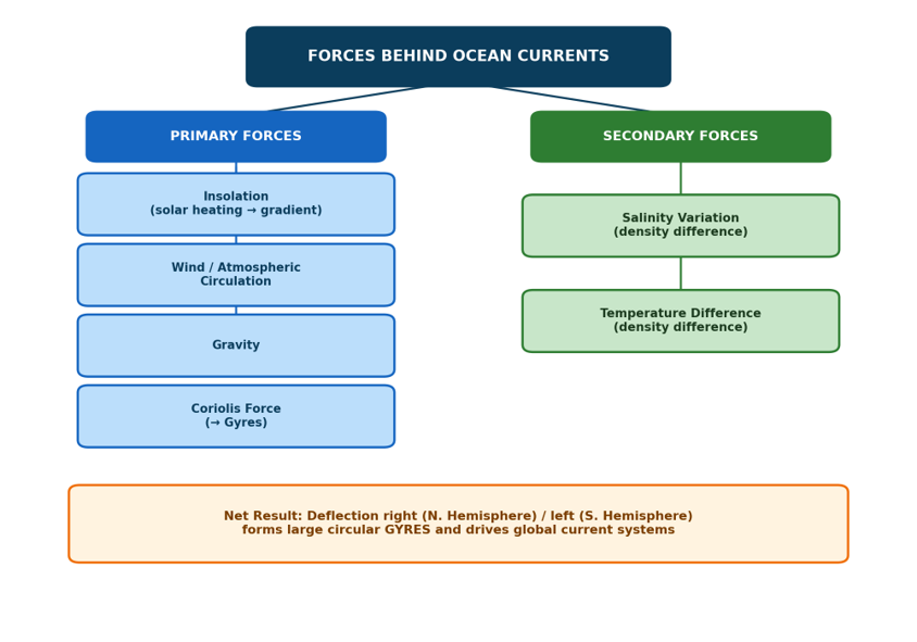
● (a) Insolation (Solar Heating):
○ Heating by solar energy causes ocean water to expand thermally. As a direct result, ocean levels near the Equator stand slightly higher — by around 8 cm — than they do at the mid-latitudes.
○ This small difference in sea level creates a very slight gradient across the ocean surface, and water tends to flow gently 'downhill' along this gradient. The resulting flow is normally oriented from east to west.
○ While the gradient itself is minor, it works continuously and, combined with wind and the Coriolis effect, contributes meaningfully to the overall current pattern.
● (b) Wind (Atmospheric Circulation):
○ Winds blowing across the ocean surface exert a frictional (dragging) force on the water immediately beneath them, physically pushing that water in the direction the wind is blowing.
○ Wind is responsible for both the strength (magnitude) and the direction of ocean currents — though the direction is further bent by the Coriolis effect once the water is set in motion.
○ Because of this, the pattern of oceanic circulation closely mirrors the pattern of the Earth's atmospheric circulation: anticyclonic (high-pressure) systems typically dominate the mid-latitudes — this pattern is more pronounced in the Southern Hemisphere than in the Northern Hemisphere, largely because the Southern Hemisphere has far less landmass to disrupt the wind flow — while cyclonic (low-pressure) systems are more common at higher latitudes, and the ocean circulation beneath follows the same broad pattern.
○ In regions of pronounced monsoonal wind flow — most notably the Northern Indian Ocean — the monsoon winds cause the ocean currents to reverse direction according to the season. This seasonal reversal is a hallmark feature of the Indian Ocean and is frequently tested in examinations.
● (c) Gravity:
○ Gravity constantly pulls ocean water downward. Where solar heating or wind action has piled water up in one place (creating a mound or gradient), gravity acts to pull that piled-up water back down the slope, contributing to the overall gradient-driven flow of currents.
● (d) Coriolis Force:
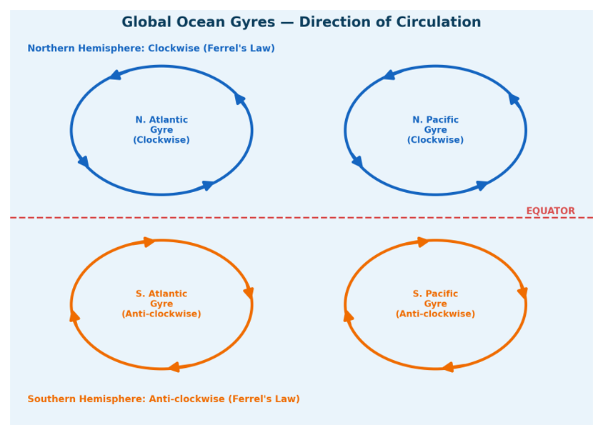
○ The Coriolis effect arises from the Earth's rotation on its axis. It deflects any moving body of water (or air) to the right of its direction of travel in the Northern Hemisphere, and to the left of its direction of travel in the Southern Hemisphere.
○ This continuous deflection, acting on water that is already being pushed by wind, causes the water to curve into large circular current systems known as Gyres, found in every major ocean basin.
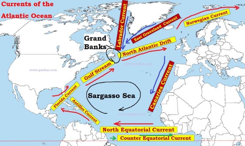
○ A well-known example is the Sargasso Sea in the North Atlantic Ocean — a region of unusually calm, still water bounded on all sides by four different currents that together form a circular gyre. Its circulatory pattern is a direct product of wind movement combined with the Coriolis effect.
3.2 Secondary Forces
While the primary forces above set water into horizontal motion, the secondary forces below govern the vertical movement of water and are together responsible for the process known as thermohaline circulation.
● (a) Salinity Variations in Water:
○ Variations in water density — themselves driven jointly by temperature and salinity — are what drive the vertical movement of ocean currents.
○ Water with higher salinity is denser than water with lower salinity, and in an entirely parallel way, colder water is denser than warmer water.
○ Because denser water tends to sink while relatively lighter water tends to rise, this density difference sets up a continuous vertical circulation within the ocean.
● (b) Temperature Differences of Water:
○ In the polar regions, water is cold and hence dense; this cold, dense water sinks and then gradually creeps along the ocean floor toward the Equator, forming cold-water currents at depth.
○ Conversely, warm-water currents originate at the Equator, where solar heating keeps surface water warm and comparatively light. This warm water flows along the surface toward the poles, replacing the water that has sunk there.
○ Together, this exchange — cold water sinking and creeping equatorward at depth, warm water flowing poleward at the surface — forms the global 'conveyor belt' that redistributes heat around the planet, influences climate patterns over the long term, and helps maintain the temperature balance that marine ecosystems depend on.
3.3 Causes of Ocean Currents
Some sources present the origin of ocean currents slightly differently, listing five direct 'causes' rather than splitting forces into a primary/secondary hierarchy. Since both framings are used in reference material, it is worth knowing this version too — the underlying physics is the same, just organised differently.
● (i) Planetary Winds:
○ Planetary winds — winds that blow continuously and consistently in a particular direction — are one of the most important causes of ocean currents. They drag the surface water along with them through the force of friction, and most of the world's ocean currents follow the direction of these prevailing or planetary winds.
○ Example: the Equatorial Currents flow westward under the influence of the northeast and southeast Trade Winds. Similarly, the North Atlantic Drift (in the Atlantic) and the North Pacific Current (in the Pacific) move in a north-easterly direction under the influence of the Westerlies.
● (ii) Variation in Sea-Water Temperatures:
○ There are marked variations in both the horizontal and vertical distribution of ocean temperature. Temperatures are considerably higher at the Equator than at the poles.
○ As a result, in the equatorial region the density of water decreases because of high temperature and heavier rainfall. This lighter equatorial water then moves toward the colder, denser water found in the polar regions, setting up a current.
● (iii) Variation in Water Salinity:
○ The amount of dissolved salts in seawater varies considerably from one part of the ocean to another. Water with high salinity tends to sink and move below water of lower salinity, generating a current at the surface that flows from the area of low salinity toward the area of high salinity.
○ There is a marked difference in salinity between the Atlantic Ocean and the Mediterranean Sea, and it is this difference that drives an ocean current flowing from the Atlantic Ocean into the Mediterranean Sea.
● (iv) Rotation of the Earth (Coriolis Force):
○ The Earth rotates on its axis from west to east, and this rotation produces a deflective force — the Coriolis force — which bends the general direction of both winds and ocean currents.
○ Currents flowing from the Equator toward the North and South Poles are deflected to their right in the Northern Hemisphere and to their left in the Southern Hemisphere. The counter-equatorial currents are also a direct result of the Earth's rotation.
● (v) Configuration of the Coastline:
○ The shape and configuration of coastlines has a close influence on the direction and movement of ocean currents, often obstructing a current and splitting it into separate branches.
○ Example: the Equatorial Current, on being obstructed by the Brazilian coast, bifurcates into two branches — the northern branch is called the Caribbean Current, while the southern branch is called the Brazilian Current.
○ In the Indian Ocean, the monsoon currents closely follow the shape of the coastlines they run alongside.
4. Key Characteristics of Ocean Currents
Beyond simply knowing what drives ocean currents, UPSC frequently tests the behavioural characteristics that emerge from these forces — how currents move, where they meet, and how coastlines and salinity shape them. Each of these characteristics is explained below.
4.1 Coriolis Effect & General Movement of Currents
● The general movement of ocean currents follows a clockwise direction in the Northern Hemisphere and an anticlockwise direction in the Southern Hemisphere, primarily due to the Coriolis force. This consistent pattern is formally known as Ferrel's Law, and it is one of the most repeatedly tested facts in this topic.
● Important Exception: The Indian Ocean does not follow this rule rigidly. Here, the direction of currents reverses seasonally in direct response to the monsoon winds — flowing one way during the Southwest Monsoon (June–October) and the opposite way during the Northeast Monsoon (winter). This exception is worth memorising precisely because it is an exception.
4.2 Movement of Warm and Cold Currents
● As a general rule, warm currents typically move toward colder regions, while cold currents typically flow toward warmer seas — this is simply water seeking to balance out temperature differences across the globe.
● In low latitudes, warm currents flow along the eastern coasts of continents, while cold currents flow along the western coasts.
● This pattern reverses at higher latitudes: here, warm currents flow along the western coasts, while cold currents flow along the eastern coasts.
● This reversal (already illustrated in Fig 2.1) is one of the most important spatial patterns to internalise, since a large share of exam questions on desert formation, rainfall, and coastal climate hinge on correctly identifying whether a given coast experiences a warm or cold current.
4.3 Convergence and Divergence
● Convergence: This occurs when warm and cold currents meet. Such meetings often lead to mixing of water masses and to nutrient upwelling from below, which in turn supports rich marine life — this is precisely the mechanism behind the world's greatest fishing grounds.
● Divergence: This happens when a single current splits into multiple currents flowing in different directions. Divergence facilitates the distribution of heat and nutrients across much larger oceanic areas than a single unbranched current could reach.
4.4 Coastal Influence
● The shape and position of coastlines significantly influences the direction and movement of ocean currents. Coastal topography can effectively guide a current along a particular path, or force it to bend, split, or intensify, thereby directly affecting its flow pattern
4.5 Subsurface Currents
● Ocean currents are not confined only to the surface — they also occur beneath the water at depth, generated by differences in salinity and temperature just as thermohaline circulation is.
● A classic example: the dense, highly saline water of the Mediterranean Sea sinks and flows outward as a subsurface current past the Strait of Gibraltar into the Atlantic Ocean, even as comparatively fresher Atlantic water flows inward at the surface to replace it.
5. Thermohaline Circulation — The Global Conveyor Belt
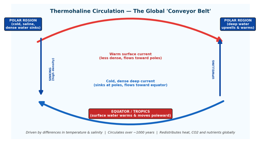
Thermohaline circulation is the name given to the vast, planet-spanning system that links the surface currents and the deep-water currents described in Section 2.1 into one continuous loop. Because this system depends on both temperature ('thermo') and salinity ('haline') differences, it is called thermohaline circulation, and is popularly nicknamed the 'global conveyor belt'.
● It is driven by differences in temperature and salinity between different parts of the ocean, both of which control the density of seawater.
● Cold, dense, highly saline water sinks at high latitudes (the polar regions) and then flows very slowly along the deep ocean floor toward the Equator.
● To replace this sinking water, warm surface water flows from the Equator toward the poles, completing the circulation loop.
● This is a vast, interconnected system of both surface currents and deep currents that circulates throughout the world's oceans over thousands of years — a single circuit is estimated to take roughly 1,000 years to complete.
● Over this immense timescale, thermohaline circulation has an outsized impact on climate stability, and it governs the long-term cycling of carbon dioxide and nutrients throughout the oceans — making it one of the key regulators of Earth's climate system.
6. Major Ocean Currents — Ocean-wise
This section lists the major named currents in each ocean basin, along with their nature (warm/cold/seasonal) and the key facts most likely to be tested — alternate names, which gyre or larger system they belong to, and their principal climatic or navigational significance. These are best learnt ocean-by-ocean, cross-referencing the world map as you go.
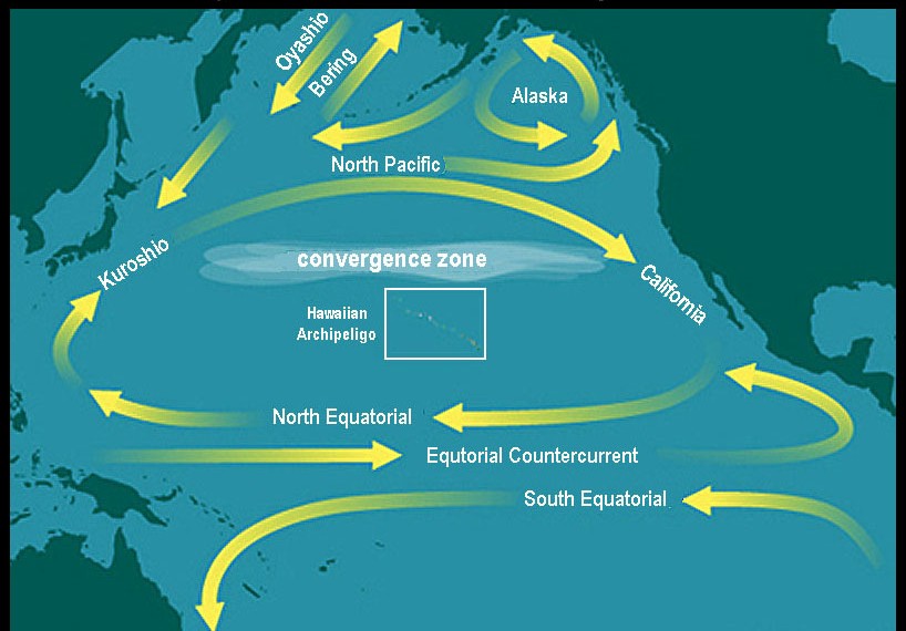
6.1 Pacific Ocean
|
Current |
Nature |
Key Facts |
|
Antarctic Circumpolar Current (ACC) |
Cold |
Also called West Wind Drift; flows clockwise (W→E) encircling Antarctica; connects Atlantic, Pacific & Indian Oceans |
|
Humboldt / Peruvian Current |
Cold |
Low-salinity, nutrient-rich; flows from S. Chile to N. Peru along S. America's west coast |
|
California Current |
Cold |
Extension of Aleutian Current; part of North Pacific Gyre; strong upwelling zone |
|
Kuroshio (Japan/Black Current) |
Warm |
Pacific analogue of Gulf Stream; west boundary current; warms Japan's climate |
|
North Pacific Current |
Warm |
Formed by collision of Kuroshio & Oyashio; circulates counter-clockwise in W. North Pacific |
|
Alaskan Current |
Warm |
Northward diversion of part of the North Pacific Current |
|
East Australian Current |
Warm |
Western boundary current of South Pacific Subtropical Gyre; along Australia's east coast |
|
Kurile / Oyashio |
Cold |
Sub-arctic; counter-clockwise; nutrient-rich; meets Kuroshio to form North Pacific Drift |
6.2 Atlantic Ocean
|
Current |
Nature |
Key Facts |
|
East Greenland Current |
Cold |
Low-salinity current between Fram Strait & Cape Farewell; connects Arctic to N. Atlantic; major sea-ice export route |
|
Benguela Current |
Cold |
Branch of West Wind Drift; eastern S. Atlantic Gyre; low salinity; strong upwelling & rich fishing zone |
|
Falkland (Malvinas) Current |
Cold |
Branch of ACC; meets warm Brazil Current forming the Brazil–Malvinas Confluence Zone |
|
Florida Current |
Warm |
Starts in Gulf of Mexico → Florida Straits → continues as the Gulf Stream |
|
Gulf Stream |
Warm |
Western-intensified, wind-driven; splits into North Atlantic Drift & Canary Current |
|
Norwegian Current |
Warm |
Branch/extension of North Atlantic Drift; one of two dominant Arctic inflows |
|
Brazilian Current |
Warm |
Flows along S. Brazil coast to Rio de la Plata; meets cold Falkland Current |
|
Labrador Current |
Cold |
Flows from Arctic southward; meets warm Gulf Stream — forms rich fishing grounds & fog |
6.3 Indian Ocean
|
Current |
Nature |
Key Facts |
|
Northeast Monsoon Current |
Seasonal |
Indian North Equatorial Current flows SW/W across the Equator (winter monsoon) |
|
Somali Current |
Seasonal / Warm |
Generated by SW monsoon along E. Africa; analogous to Gulf Stream; major upwelling zone |
|
West Australian Current |
Cold |
Also 'West Wind Drift'; part of ACC; seasonal — strong in summer, weak in winter |
|
Mozambique Current |
Warm |
Flows between Mozambique & Madagascar (Mozambique Channel) |
|
Agulhas Current |
Warm |
Western boundary current of S. Indian Ocean; largest western boundary current; flows south along E. Africa |
|
Southwest Monsoon Current |
Seasonal |
Dominates June–October; broad eastward flow into Arabian Sea & Bay of Bengal |
Note: The Indian Ocean is unique — its currents reverse direction seasonally in response to the monsoon (Northeast vs Southwest Monsoon Currents).
6.4 Equatorial Current System (All Oceans except Arctic)
● North & South Equatorial Currents: Flow east → west, driven by trade winds; present in all major oceans except the Arctic.
● Equatorial Counter Current: Flows west → east, positioned between the North and South Equatorial Currents, balancing equatorial water movement.
7. Impact of Ocean Currents on Regional Climate, Fishing & Navigation
● 7.1 Impact on Climate
Desert Formation: Cold ocean currents cool the air above them, sharply lowering its moisture-holding capacity. This produces coastal aridity and fog on adjoining land — the classic example being the cold Humboldt (Peruvian) Current, which drives the formation of the Atacama Desert, one of Earth's driest regions.
● Most major hot deserts lie between 15°–30° N/S latitude on continents' western coasts, within the Horse Latitudes (Sub-Tropical High-Pressure Belts), where descending air suppresses rainfall.
● They're called "Trade Wind Deserts" because the off-shore Trade Winds blowing across them carry moisture away rather than inland, while the moisture-bearing Westerlies pass well outside their limits.
● Any wind that does reach these deserts moves from cooler to warmer areas, warming further and losing humidity — leaving skies mostly cloudless and relative humidity as low as 30% inland (vs. ~60% on the coast).
● On western coasts, cold currents chill the overlying air into mist and fog; by the time this air moves inland and warms, it has already lost most of its moisture, so little rain falls.
● The Peruvian Current's drying effect is so strong that the Atacama receives only ~1.3 cm of rain annually — likely the driest non-polar desert on Earth.
● Major deserts formed this way include the Sahara (largest, ~3.5 million sq. miles), Great Australian Desert, Arabian, Iranian, Thar, Kalahari, and Namib Deserts.
● Impact on Rainfall Patterns: Warm ocean currents, by contrast, are responsible for bringing rain to coastal regions and, in some cases, even to areas well inland. In tropical and sub-tropical latitudes, warm currents typically flow parallel to the east coasts of continents, and this contributes to warm, rainy climates in regions such as Florida (USA) and Natal (South Africa).
○ These regions lie on the western margins of sub-tropical anticyclones, and as a result they experience significant rainfall, particularly during the summer months.
● Moderating Effect on Coastal Temperatures: Ocean currents play a major role in moderating temperatures along the coastlines they touch. For instance, the North Atlantic Drift carries warmth to Western Europe, and especially to the British Isles (a group of islands in the North Atlantic Ocean), preventing the extremely cold winters that would otherwise be expected at that latitude.
○ Conversely, the Canary Current — a cold current off the western coast of Africa — has a cooling effect on Spain, Portugal and the surrounding regions, moderating what would otherwise be a hotter climate.
● Role in Tropical Cyclones: Warm ocean currents play a significant role in both the formation and the subsequent intensification of tropical cyclones. These currents accumulate warm water in tropical regions, and this warm water provides the energy that fuels the development of cyclonic storms. The Indian Ocean and the Atlantic Ocean are both notably affected by this process.
7.2 Impact on Fishing
● Rich Fishing Grounds: The mixing of cold and warm ocean currents creates some of the richest fishing grounds anywhere in the world. Such areas are rich in nutrients and plankton, which serve as the primary food source for fish populations. Well-known examples include the Grand Banks near Newfoundland, Canada, and the north-eastern coast of Japan, both renowned for their abundant marine life.
○ The movement and mixing of ocean currents helps replenish oxygen levels in the water and promotes the growth of plankton — together, these effects make such convergence zones ideal locations for commercial fishing.
● Drizzle and Fog Formation: The meeting of warm and cold ocean currents very often leads to the formation of foggy weather, where precipitation occurs mainly in the form of a light drizzle. This phenomenon is particularly noticeable in regions like Newfoundland, where the cold Labrador Current meets the warm Gulf Stream, resulting in foggy conditions that affect both navigation and local weather patterns in the area.
7.3 Impact on Navigation
● Ocean currents aid maritime navigation by directly influencing ship routes. Currents such as the North Equatorial Drift assist ships travelling westward — for example, a vessel moving from Mexico to the Philippines can make use of this current to speed its journey.
● Conversely, when ships need to travel eastward — such as from the Philippines back to Mexico — they can instead take advantage of the counter-equatorial currents, which flow in the opposite direction.
● A thorough understanding of ocean currents — including their direction, strength and seasonal variability — is therefore crucial for optimising maritime navigation routes and for enhancing fuel efficiency across global trade, since sailing with a favourable current can meaningfully cut both travel time and fuel consumption.