Roadways
India has one of the largest road networks in the world
Traffic through Roads-
- About 70% of freight
- 85% of traffic
History of Road development in India
- Indus valley civilization- Paved roads were constructcted
- There were also some road developemnet during Maurayan period and Mughal rule
Efforts of Sher Shah Suri-
- Sher Shah Suri constructed a road which connected Peshawar to Kolkata.
- It was named as the Grand Trunk Road (G.T. Road). During Britishers time The Grand Trunk Road following the old Mughal Road from Dhaka in Bangladesh to Lahore in Pakistan was the most important road connecting all the premier cities in the North India.
- Now, the G.T. Road joins Amritsar with Kolkata after partition of India. Presently, it is known as “Sher Shah Suri Marg”.
History of Road development Initiatives
1.Nagpur Plan
- It was drawn in 1943
- This plan envisaged increasing of the kilometre age of major roads to 1, 96,800 km and of other roads to 3, 32,800 km by 1953.
- The highlight of the plan was that no village in a developed agricultural region should be more than 8 km from a major road or 3 km away from any other road while the average distance of villages from a major road should be less than 3.2 km.
- In a non-agricultural region, these distances were fixed at 32, 8 and 10 km respectively.
- There was failure of this Plan due to prevailing economic condition of India at that time
2.Twenty Year Road Plan
- It was started in 1961.
objectives-
- Increase the total length of roads from 6.56 lakh km to 10.60 lakh km.
- Achieve a road density of 32 km per 100 sq. km by 1981.
- Ensure that every village located in a developed agricultural area is within a 6.4 km distance of a metalled road.
- Ensure that every village located in a semi-developed area is within a 12.8 km distance of a metalled road.
- Ensure that every village located in an undeveloped and uncultivated area is within a 19.2 km distance of a metalled road and 8 m of any other road.
3.The Rural Development Plan
- It includes construction of rural roads under Minimum Needs Programme (MNP), Rural Landless Employment Guarantee Programme (RLEGP), Jawahar Rojgar Yojana (JRY) and Command Area Development (CAD) programmes to collect all villages having a population of 1,500 or more with all weather roads and those having less than 1,500 population with the link roads
4.The Central Road Fund (CRF)
- It is a non-lapsable fund created under Central Road Fund Act 2000
- Money raised-It is procured out of the out of cess/tax imposed by the Union Government on the consumption of Petrol and Diesel
Use-
- It should be used to develop and maintain National Highways, State roads (that have economic importance with inter-state connectivity), rural roads, railway under/over bridges etc, and national waterways ( from 2017 onwards )
- Construction of road under/over bridges and safety works at unmanned railway crossings, disbursement in respect of such projects as may be prescribed by the Government
The Central Road Fund (Amendment) Bill, 2017
- This amendment included Waterways development under the eligible projects of CRF
5.Pradhan Mantri Gram Sadak Yojna-
- To address poverty reduction, the Indian government initiated the Pradhan Mantri Gram Sadak Yojana (PMGSY).
- Atal Bihari Vajpayee, the former Prime Minister of India, introduced this Centrally Sponsored Scheme in 2000.
- The Ministry of Rural Development oversees the implementation of PMGSY, which aims to provide connectivity to unconnected habitations.
Objective
- The main goal of PMGSY is to establish connectivity to eligible unconnected rural areas.
- The connectivity is provided by constructing all-weather roads with necessary culverts and cross-drainage structures.
- The roads must be operable throughout the year.
- The eligible unconnected habitations must have a population of at least 500 persons in plain areas according to the 2001 census.
- In special category states, the eligible unconnected habitations must have a population of at least 250 persons.
Classification of Roads
1.National Highways-
- National highways account for 2% of the total road network and carry over 40% of total traffic.
- For interstate connectivity
- The Central government is responsible for the development and maintenance of National Highways System
Three Major authorities works for its development
National Highway Authority of India (NHAI)
State Public Works Department (PWD)
Border Roads Organization (BRO)
- The National Highways constitute only 2 percent of the total road length but carry 40 percent of the road traffic.
- Uttar Pradesh have maximum length of National Highway.
2.State Highways: -
- State highways are constructed and maintained by the state P.W.Ds.
- These provide link to all major towns and cities of the state, state capitals and district headquarters.
- These constitute 4 percent of the total road length in the country.
- As per census 2011, the total length of state highways was 163,898 km. Among the state Maharashtra has the longest network of state highways followed by Karnataka, Gujarat, Rajasthan and Tamil Nadu.
- These five states together have 57% of the total state highways of the country.
3.District Roads: -
- These roads mostly connect the towns and large villages with the district headquarters.
- They make up 14% of the country's total road length.
4.Village Roads: -
- Village Roads are constructed and maintained by the village Panchayats.
- The category includes the village panchayat roads, Panchayat Samiti roads and rural roads constructed under the Jawahar Rozgar Yojna .
- About 80 percent of the total road length in India are categorized as rural roads.
Other Types-
1.International Highways-
- These are highways that provides connectivity to different countries
- They are generally funded by International economic organizations like World bank etc.
2.Express Highways: -
- These are multi-lane well paved highways with controlled access for fast movement of goods and traffic
Different Programmes /schemes related to Road Transportation-
1.The Bharat Mala Project
- The "Bharat Mala" initiative is planned across 13 states, covering a 5300 km distance from Gujarat to the Indo-Myanmar border of Manipur and Mizoram, passing through Rajasthan, Punjab, J&K, Uttarakhand, UP, Bihar, Sikkim, Assam, and Arunachal Pradesh.
- The project's objectives include enhancing accessibility to border areas, boosting border trade, and countering China's network build-up across the border.
- The strategic aspect of the Bharat Mala project focuses on securing India's borders and promoting economic development in remote regions.
Its components include-
- Economic Corridor
- Feeder Route or Inter Corridor
- National Corridor Efficiency Improvement
- Border Road and International Connectivity
- Port Connectivity and Coastal Road
- Green Field Expressway
- Balance NHDP Works
2.Setu Bharatam
It was launched by Ministry of Road Transport and Highways
Objective & Features:
- Aim to make all National Highways free of railway level crossings by 2019.
- To prevent the frequent accidents and loss of lives at level crossings.
3.National Highway Development Project (NHDP):
Under this programme following projects were launched
A. Golden Quadrilateral
- It is a 6-lane highway project
- It provides connectivity to4 major cities of the country
Delhi – Mumbai – Kolkata – Chennai
- This project will be implemented in different phases and will provide connectivity to N-S and East -West part of India
B. North – South Corridor
- This project focuses on connecting Northern part of India with Southern part
- Connect -Srinagar – Kanyakumari
C. East – West Corridor
- It will provide connectivity to eastern and western part of the country
- Connect - Silchar (Assam) – Porbandar
4.Char Dham Project-
- Char-Dham Road Project is a prestigious two-lane expressway project.
- The Ministry of Road Transport and Highways is executing this program in Uttarakhand.
- It will connect-Yamunotri, Gangotri, Badrinath, and Kedarnath.
- Implementing Agencies: Uttarakhand State Public Works Department (PWD), Border Roads Organisation (BRO), and the National Highway & Infrastructure Development Corporation Limited (NHIDCL).
5.ePACE (Projects Appraisal & Continuing Enhancements)
- Under Ministry of Road Transport and Highways
- The aim is to develop an online Management Information System.
- The system will integrate projects from all departments of the Ministry.
- The goal is to ensure effective and real-time tracking of projects.
- The system will provide a common platform for all projects.
6. NATRIP
- The Department of Heavy Industry will oversee the National Automotive Testing and R&D Infrastructure Project (NATRIP), which will include members from the automobile industry.
- The objective of NATRIP is to establish testing, validation, and R&D facilities in seven different locations throughout India.
Problems of Road Transport
1.Low Private Participation
2.Lack of connectivity in Rural areas
3. Inadequate Side Amenities
4. Unmetalled Roads and their Improper Maintenance
5. Congested roads in Urban Areas
6.Old and narrow Bridges on the roads
Importance of Roads
1.Help in economic development of the country and region
2.Tribal development
3.Access to Rural areas
4.Tourism development
5.Access to coastal and port areas
Facts-
- The longest highway in India - National Highway 44.
- The shortest highway in India - NH 47A.
- Highest highway in India - Khardung La Highway.
Some National Highways
- NH-1-Delhi-Amritsar
- NH-2-Delhi-Kolkata
- NH-3-Agra-Mumbai
- NH-4-Chennai-Thane
- NH-5-Chennai-Cuttack
Railways
- The Indian Railways is recognized as one of the largest rail networks worldwide. The railway network in India ranks 4th globally and 2nd in Asia under a single management system.
Railway Gauges
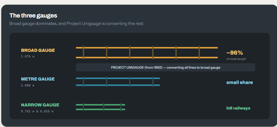
- Broad Gauge = 1.675 m (96 %)
- Meter Gauge = 1 m
- Narrow Gauge = 0.762 m and 0.610 m (5.36 %)
History of Indian Railways-
- The inception of the idea to introduce railways in India dates back to 1832 when the initial proposals were made in Madras.
- 1st Train on 16 April 1853
- India’s first passenger train, operated by the Great Indian Peninsula Railway
- It consisted of Three locomotives named as– Sahib, Sindh and Sultan –
- Distance- 34 kilometres with 400 people in 14 carriages on 1,676 mm broad gauge track Between Bori Bunder (Mumbai) and Thane.
- The Thane viaducts are historically significant as they mark the construction of India's inaugural railway bridges.
- They were erected over the Thane creek as an extension of the Mumbai-Thane line and became operational in May of 1854, providing a crucial transportation link to Kalyan.
Factors affecting Railways development
A. Geographical factors
1.The North Indian plain-
- The favorable conditions for railways' development lie in the North Indian plain due to its level land, dense population, and thriving agriculture.
- However, the construction of bridges over a significant number of rivers in the region incurs substantial expenses.
2.The plateau region of south India-
- Unlike the North Plain area, the plateau region of South India poses challenges for railway construction and operation.
- The undulating terrain in the South Indian plateau region creates obstacles for building new railway projects.
- Operational difficulties are also a concern for railways in the plateau region of South India.
- Additionally, the concentration of population is lower in this region, making it less of a priority for railway development.
- Hence, the suitability of the plateau region for railways is comparatively lower than the North Plain area.
3.The Himalayan region-
- Due to its rugged topography, the Himalayan region in the north has a lack of railways.
- Railway terminals can be found on the foothills of the Himalayan region, including Jammu Tawi, Kotdwar, Dehra Dun, and Kathgodam.
- The Himalayan region has a few narrow gauge railway tracks.
4.The sandy areas of Rajasthan-
- Railway transportation is not optimal in the sandy regions of Rajasthan.
- The absence of a railway line between Jodhpur and Jaisalmer continued until 1966.
- The lack of railway infrastructure can be attributed to various factors such as low population density, the absence of industries, and challenging terrain.
5.Forested areas-
- The growth of railways is hindered in Madhya Pradesh and Orissa's forested regions, West Bengal's deltaic swamps, the marshy areas of Rann of Kachchh, and Sahyadri's hilly terrain.
- To reach coastal trailheads such as Mumbai, Vasco-de-Gama, Mangalore, and Kochi, only gaps like Thalghat, Bhorghat, and Palghat can be used to cross Sahyadri.
B. Economic factors
- Economically developed regions such as Delhi, Northern Plains, and Mumbai tend to have better railway networks due to higher demand.
- The presence of economic linkages leads to a higher concentration of railways around significant urban and industrial centers such as Jamshedpur.
- Areas that are abundant in mineral and agricultural resources also tend to have a denser railway network.
3.Political and Administrative factors
- The current railway system in India is a legacy of British rule.
- During British rule, railway lines were planned in a way to exploit India's raw materials for British industries and flood Indian markets with British goods.
- The construction of railways was also necessary for maintaining British military supremacy and quick movement of troops and arms.
- The top priority was given to connecting big ports like Mumbai, Kolkata, and Chennai to their hinterlands to facilitate imports and exports.
- The railway network gradually spread from these ports to other parts of the country.
- The political factor played a major role in establishing the rail coach factory in Rai Bareli, as it is the constituency of some prominent politicians in the country.
Distribution of Indian Railways
1. North Indian Plain
- The North Indian Plain boasts a dense railway network that stretches from Amritsar to Kolkata.
- This region is known for its robust economic development and high population density.
- The North Indian Plain is one of the most densely populated and economically thriving areas in India.
- From Amritsar to Kolkata, the North Indian Plain has an extensive railway system that facilitates transportation and trade.
- This region is characterized by a dense population and a strong economy, supported by a well-connected railway network.
- This densely populated region has highly developed industry and agriculture, which has in turn helped in the development of railways.
- Delhi is the main point from where railway lines radiate in all directions.
2. Peninsular India:
- Due to the hilly and plateau terrain and moderate population density these is moderate or loose network of railway
- Trunk routes that traverse the Indian peninsula offer convenient rail transportation between major cities such as Mumbai-Chennai, Chennai-Kochi, Chennai-Delhi, and Mumbai-Kolkata.
3.Himalayan Region:
- Railway is poorly developed in this area due to Hilly terrain
- There are three narrow gauge railway lines in the Himalayan region. These are Kalka-Shimla, Pathankot- Kangra and Siliguri-Darjeeling.
Some railways of this regions-
- The Kalka-Shimla Railway built in 1903 winds itself through picturesque country from Kalka to Shimla over a distance of 97 km. It has 103 tunnels, totalling 8 km in length; the longest tunnel is 1,144 metres.
- The Siliguri-Darjeeling Railway is 82 km long and was constructed in 1878.
- Udhampur-Srinagar Baramula railway - The government has taken up an ambitious and challenging programme of constructing 291 km long Udhampur-SrinagarBaramula railway line, like the earlier constructed 55 km long Jammu Tawi-Udhampur railway line
- The Udhampur-Srinagar-Baramula railway line is proposed to have 80 tunnels, the highest passing through the Pir Panjal Range of 14.5 km length.
4. Coastal Plains:
- Eastern coast has good Railway line as comparison to Western coasts due to emerged coastal area in eastern coasts and Submerged coastal area in western ghats
- The Konkan Railway line is located along the western coast of India, stretching from Roha to Mangalore.
- It traverses through several tunnels and bridges along the way, including the longest tunnel in India which is approximately 6.5 km long and situated around 23 km south of Ratnagiri. The project is a collaborative effort between the states of Maharashtra, Goa, and Karnataka.
Problems of Indian Railways
1.Poor Infrastructure
Infrastructure like old Track and Poor State of Rolling Stock is one of the major problems of Indian railways
2.Lack of Modern Technologies-
Our Railway is still running on age old technologies and need to update the existing technical components
3. Heavy Pressure-
With the increase in population, industrialization and urbanization there is a heavy pressure of passengers and goods on the railways.
4.Competition with Road Transport-
Railways are facing tough competition from road transport. Many a times a road transport is preferred as roads can deliver the goods at the doors.
5. High Rates of Electricity and Diesel-
The increase in the price of the diesel affects the finances of the railways adversely also prices of electricity have adversely affected financial positions of the railways
6.Problem of Laying Double Lines-
Many of the railway lines only have one track, causing significant inconvenience for both railway staff and passengers.
7.Lack of Private Investment-
Indian railways lacking Private and international level investment which somehow creates reluctance for utilization of new and innovative technologies
8.Role of industries –
Industrial slow down as contributed to the drop in the railway freight business.
Importance of Indian Railways-
1.Cheaper and easy mode of Transportation in India
2.Provide connectivity to Rural and inaccessible areas
3.It is one of the fastest and cheapest mode of transportation
4.It helps in agricultural development of the country by linking Agricultural centres with Proper and nearby market
5.It helps in Industrial development as it provides easy transportation for Raw material required for industrial production
6.It helps in Promotion of National Integration
7. Cheapest Mode of Transportation for Bulky Materials like coal, petroleum and mineral ores
8. Railway helps in the defence and internal security of the countryby ensuring the quick movement of troops, defence equipment, etc to remote places.
Initiative for Railway development in India
1. Dedicated Freight Corridor (DFC)
- The Dedicated Freight Corridor (DFC) is a railway corridor designed for transporting goods and commodities at high speeds and capacities.
- The DFCCIL, which operates under the Ministry of Railways, is responsible for planning and completing 3,306 kilometers of DFCs.
- The purpose of the DFCCIL is to create a specialized railway network solely for freight transportation.
- The DFC aims to improve the efficiency and speed of freight transportation in India.
- The DFCCIL has implemented advanced technologies and infrastructure to support the efficient movement of goods on the DFC.
DFC consists of two arms:
A.The Eastern Dedicated Freight Corridor (EDFC)
- The Eastern Dedicated Freight Corridor (EDFC) is supported financially by the World Bank.
- The EDFC originates from Sahnewal (Ludhiana), Punjab and terminates at Dankuni, West Bengal.
- Along the EDFC route, there are coal mines, thermal power plants, and industrial cities.
- Additionally, feeder routes are being constructed to connect these locations.
B. Western Dedicated Freight Corridor (WDFC):
- The Western Dedicated Freight Corridor (WDFC) spans around 1,500 km from Dadri in Uttar Pradesh to Jawaharlal Nehru Port Trust in Mumbai.
- The WDFC passes through all major ports along the way.
- Funding for the WDFC is being provided by the Japan International Cooperation Agency.
2. Diamond Quadrilateral
- The Diamond Quadrilateral is a project of the Indian railways to establish a high-speed rail network in India. The Diamond Quadrilateral will connect the four mega cities of India, viz. Delhi, Mumbai, Kolkata and Chennai, similar to the Golden Quadrilateral highway system.
- High-speed train on Mumbai-Ahmedabad section will be the first high-speed train corridor to be implemented in the country.
3.Metro rail-
- The metropolitan cities of India provide a quick, affordable, and convenient travel experience through the Metro Rail network.
- The launch of the Delhi Metro in 2002 marked the introduction of India's first modern metro and the third rapid transit system in the country.
4. Rashtriya Rail Sanraksha Kosh
- It was created in 2017-18 with a corpus of ₹1 lakh crore over a period of five years
- A non-lapsable fund named Rashtriya Rail Sanraksha Kosh is established.
- The fund will be dedicated to enhancing safety measures on the Indian Railways network.
- The primary goal of the fund is to assist Indian Railways in achieving its zero-accident mission.
- The fund will be utilized in a comprehensive manner to strengthen safety measures.
5. Project Saksham:
- It is a comprehensive training programme launched by Indian Railways.
- It is an up skilling exercise to upgrade skill and knowledge will be held for all employees of Indian Railways.
6. Bharat Gaurav Scheme
- This scheme was launched by Indian Government to tap the huge potential of Tourism in India.
- Under it, trains have a third segment for tourism. Before this scheme was launched, Railways had goods segments and passenger segments.
- These trains are not regular trains, and will run according to timetable.
- It will run on the lines of Ramayana Express, which is being run by the IRCTC.
- Scheme was announced under theme-based tourist circuit trains.
Facts about Indian Railways
- The Fairy Queen is the oldest functioning steam engine in the world. It is plying between New Delhi and Alwar in Rajasthan.
- Four sites of Indian Railways have been declared as “World Heritage sites” by UNESCO. They are Darjeeling-Himalayan Railway, Nilgiri Mountain, Mumbai CST, and Kalka-Shimla Railways.
- Indian Railways was nationalized in 1951
- According to the Acworth Committee in 1920-21, the railway finances of India were separated from the general government finances in 1924.
- Indian Railways is the world’s seventh-largest employer with over 1.4 million employees on its rolls.
- Indian Railways’ longest tunnel is Pir Panjal that links Kashmir Valley with Banihal in Jammu.